Contents
Index
Show Road Point
The Show Road Point function can display the Road design RL and point co-ordinates,
natural surface height, thye design height (if present) and the chainage and offset on a road.
Road
Click on a Road so that the program knows which road to use when showing the design surface level
for a point.
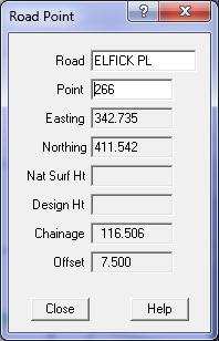
Point
To choose the point, you can click on a point on the screen, or enter the point number at the keyboard.
Type in the point number and press ENTER or TAB to fetch and display the point co-ordinates.
Easting
This will display the point Easting (X) value. It is stored to more than 6 decimal places but only
displayed to three decimal places. You can see the Easting (X) value for the mouse displayed in the
bottom left of the screen as you move the mouse.
Northing
This will display the point Northing (Y) value. It is stored to more than 6 decimal places but only
displayed to three decimal places. You can see the Northing (Y) value for the mouse displayed in the bottom
left of the screen as you move the mouse.
Nat Surf Ht
The Natural Surface height (Z) value for the point will be displayed if it has one.
If a point has no height value, this field will be blank. Computed points like lot corners will generally not have a height value. The height value is stored to more than 6 decimal places but only displayed to three decimal places.
Design Ht
The Design Surface height (Z) value for the point will be displayed if it has one.
This height will be the computed during the road design computation.
Chainage
The chainage of the point on the road will be calculated and displayed.
Offset
The chainage of the point on the road will be calculated and displayed.